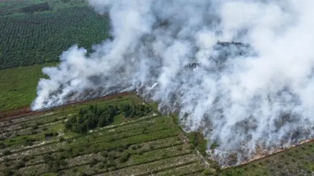
Peatland fire in Suak Puntong Village, Nagan Raya in June 2023.
The government was asked to conduct compliance audits on companies holding concessions permits in peat areas after a recent study from the Peat Monitoring NGO found millions of hectares of peatland were vulnerable to burning in this year’s dry season.
Titled Beware of Karhutla in Pelupuk Mata, the latest report said 3.8 million hectares of the Peat Hydrological Union (KHG) – including 2.5 million hectares of peatland – are in “high-class vulnerability”. As much as 54% of the 3.8 million hectares are in the concession area along with the buffer area.
Peat expert, Prof. Bambang Hero Saharjo, said the company’s compliance audit of the availability of facilities and infrastructure for preventing and tackling forest and land fires (karhutla) needs to be carried out before the fire occurs. Moreover, the El Nino phenomenon is feared to make peatlands more vulnerable to fire.
“If that’s not the case, then what is called vulnerability, it is not impossible that becomes a reality. So if that happens, the implications are heavy because greenhouse gas emissions in peat areas are one of the contributors to greenhouse gas emissions for Indonesia,” he said.
The National Disaster Management Agency (BNPB) noted that from January to July 2023 there were 211 forest and land fires — almost the same as the total of 2022.Recommended articles
An official of the Peatland and Mangrove Restoration Agency (BRGM) said he would cross-check the findings of the Peatland Monitoring NGO, but confirmed that the agency did not take care of the concession area.
High vulnerability
BETWEEN PHOTOS The National Disaster Management Agency (BNPB) noted that from January to July 2023 there were 211 forest and land fires — almost the same as the total of 2022. The Peat Monitor NGO determines locations that are statistically vulnerable to forest and land fires using regression model development methods based on forest and land fires history data from 2015 to 2019, with several variables such as hotspots and vegetation cover loss.
The data used by Peat Monitor is sourced from the Ministry of Environment and Forestry (KLHK), the Center for Research and Development of Agricultural Land Resources (BBSDLP), NASA’s Fire Information for Resource Management System (FIRMS), Global Forest Watch (GFW), and various other sources.
To illustrate the level of forest and land fires in 24.2 million hectares of Peat Hydrological Union (KHG) in Indonesia, the institution classified it into three vulnerability classes: high-class, medium-class, and low-class karhutla vulnerability.
“This means that 2.5 million hectares [peatland] that are in this high-class vulnerability means that he has the potential for forest and land to occur, or in the sense that if we track back, maybe he has a history of forest and land,” said Almi Ramadhi from the Peatland Monitoring research team at a discussion event in Jakarta, Thursday (20/07).
“For the future. Of course we have to be on standby together, especially in the high-risk areas and also take preventive measures so that [fire] does not occur this year.”
As much as 54% of the 3.8 million hectares of KHG with high vulnerability of forest and land fires are in the concession area and its buffer area, according to Peat Monitor. Most of them are concessions with Business Use Rights (HGU) permits, which are dominated by oil palm plantations, and Industrial Plantation Forests (HTI).
Peatland Monitoring found a link between the emergence of forest and land fires and KHG areas burdened by extractive company concessions. Based on the history of forest and land fires in the 2015-2020 period at least about 30% of forest and land fires occurred in peat areas burdened with concessions — that proportion even reached 50% in 2016 and 2017.
Wahyu Perdana, one of the researchers in this study, said the concession area is a concern because the company is responsible for the fires that occur within its concession area.
“In our records, either plantation or forestry concessions have a tendency and pattern of repeated fires from year to year. At least we saw that in 2015 and 2019,” Wahyu said.
SIGIT PRASETYA/NURPHOTO VIA GETTY IMAGES Residents are trying to extinguish peatland fires using simple equipment in Arisan Jaya Village, Ogan Ilir Regency, South Sumatra, June 2022. In Indonesia, forest and land fires usually occur from February to March, then from July to October. The El Nino phenomenon, which is predicted to make drought drier, will further increase the vulnerability of forest and land fires in Indonesia.
Peat Monitor found 5,030 hotspots during January to May 2023. During that period, they also found allegations of forest and land fires in the KHG area in 29 locations.
Head of the BNPB Control and Operations Center, Bambang Surya Putra, said that his party had prepared a number of strategies to overcome forest and land fires such as the addition of tools for disaster alert in areas and Weather Modification Technology (TMC) operations if needed.
Bambang explained that in handling fires in the field, BNPB did not enter the concession area because it was the responsibility of the owner. However, if the fire grows so it requires extensive resources to handle it then BNPB will intervene.
“But when what should be the responsibility of the landowner cannot carry out security at their respective locations, then it has an impact on us to go down or the government’s resources go down, of course there are effects that may be burdensome in terms of the verdict in court; which will also be determined later the amount of losses and so on caused by that matter,” said Bambang.
The government needs a ‘compliance’ audit
Peat expert from Bogor Agricultural Institute, Prof. Bambang Hero Saharjo, said the finding of the location of forest and land fires in the concession area was actually a reminder that there was mismanagement by the corporation so that they were in a vulnerable condition. For example, the groundwater level exceeds that determined by the regulation which is 40 centimeters.
So it means that according to the regulations that there is PP and the ministerial regulation, the water level or ground water level must be less than 40 cm. So more than 40 cm he will be sensitive, so the drying process begins … Then the area will be more sensitive to fire. Now that can be indicated later from hotspots and so on,” he said.
According to Prof. Bambang, this finding should be immediately followed up by the Minister of Environment and Forestry (LHK) as well as the association of palm oil entrepreneurs by conducting a company compliance audit on the availability of forest and forest and countermeasures prevention facilities and infrastructure before the fire occurred.
If the company is not willing to make repairs, said Prof. Bambang, they can be subject to administrative sanctions.
To ensure the readiness of the corporation is not just a statement or narrative, it must be ensured by conducting a compliance audit. With the audit compliance, we get real data, the truth of the data that occurs in the field,” he said.
Because if not, and it happens like before there are neglections. It is not impossible that the vulnerable one finally came true.”
“In that way, we hope that the fire opportunity from the previous suspicion will not come true,” said Prof. Bambang.
BBC News Indonesia has contacted the Director General of Environmental Pollution and Damage Control of KLHK, Sigit Reliantoro, who oversees the Directorate of Peat Damage Control, but has not received an answer until this news article is published.
Wahyu Perdana from Pantau Gambut said one of the factors that causes fires on peatlands to continue to repeat itself is that many environmental law decisions are not executed optimally so that they do not cause a deterrent effect for burners. This problem has also been recognized by KLHK.
“Well, in the context of regulations, for example, the area that has been burned, it should not be planted before it is restored or then operated again. But the factual field is also different. Now the weak enforcement of regulations and law enforcement in our analysis then it makes repeated fires become patterns that continue to occur from year to year,” said Wahyu.
Response of government agencies and associations of palm oil companies
The official of the Peat and Mangrove Restoration Agency (BRGM) who represented the institution in the launch event of this study, Parihutan Sagala, said that he would cross-check the Peatland Monitoring findings with BRGM data.
Sagala, who serves as Head of the Head of Papua Peatland Restoration, said that the Peat Monitoring study has several limitations so that the data is not necessarily in accordance with the reality in the field.
“We can share information and data … because I think karhutla is not the task of some institutions but the task of all of us,” he told BBC News Indonesia.
Sagala said that currently BRGM continues to monitor hotspot trends as well as forest and land fires. BRGM also carried out Weather Modification Techniques (TMC) that have been done in Riau, Jambi, South Sumatra, West Kalimantan, and South Kalimantan.
He explained that the working area of BRGM in seven priority provinces – Jambi, West Kalimantan, South Kalimantan, Central Kalimantan, Papua, Riau, South Sumatra – is outside the company concession area.SIGIT PRASETYA/NURPHOTO VIA GETTY IMAGES Peatland fire in Arisan Jaya Village, Ogan Ilir Regency, South Sumatra Province, June 28, 2022. This year, El Nino is predicted to make the dry season drier — which increases the risk of forest and land fires. Responding to the results of this study, the Assurance Director Roundtable on Sustainable Palm Oil (RSPO), Aryo Gustomo, also explained that his party has used satellite technology to monitor the concession areas of companies that are members of the RSPO.
If a hot spot is found, the RSPO monitoring team will notify the company that owns the concession and the company must investigate it.
In 2021, RSPO released Hot Spot Hub, an interactive digital platform that provides information about verified hotspots and potential fires within RSPO certified and uncertified concessions, as well as highlighting actions taken by members to improve the situation.
“RSPO will continue to consider, study, review if there are inputs that can strengthen the system we have today,” said Aryo.
Aryo explained, since 2018 RSPO has included a ban on using fire to clear land and burn waste in the certification criteria for sustainable palm oil.
The RSPO also requires companies that are members to implement fire prevention as much as possible and carry out controls in the event of a fire.